Friday, October 31, 2014

Sand Forming at a Channel in Athabasca Valles


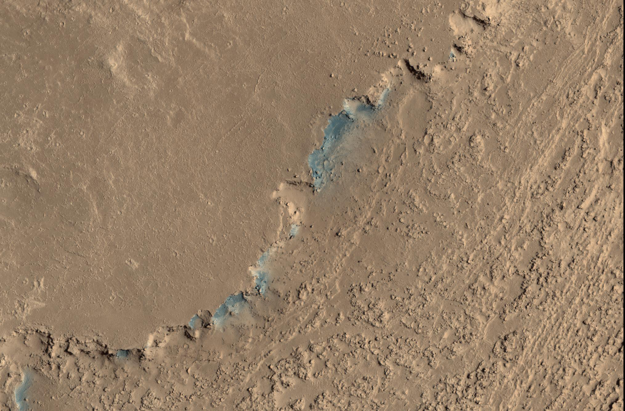
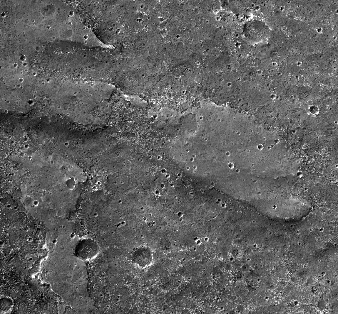
This image shows a small channel cutting into young volcanic lavas in a region where massive catastrophic flooding took place in the relatively recent past. The Athabasca Valles region includes a vast lava flow, thought to be the youngest on Mars, with even younger outflow channels that were carved by running water. The source of the water is believed to be the Cerberus Fossae valleys to the north, which may have penetrated to an over-pressurized aquifer in the subsurface.

Nowadays, erosion by gravity, wind, and frost gradually wears down the rims of the outflow channels. In this scene, we see dark materials along the channel rim that were probably exposed by this erosion. The dark materials are less red than the surrounding surface and so they appear blue in this enhanced color picture. Viewed close up, the dark materials show ripples that suggest they are made up of mobile sand. It is possible that this sand originated elsewhere and simply collected where we see it today, but the fact that sand is not found elsewhere in the scene suggest to us that it is eroding out of the volcanic layers at the retreating rim of the channel.

Sand sources are important because mobile sand grains have only a limited lifetime, wearing down and chipping apart each time they impact the surface. Erosion of the volcanic materials in this region may provide sands to replace those that are destroyed. Few such sand sources have so far been identified on Mars.

Image credit: NASA/JPL/University of Arizona

Note: For more information, see PIA18889: Sand Sources Near Athabasca Valles.

Thursday, October 30, 2014

Possible Landing Site of the Mars 3 Lander


Despite the recent successes of missions landing on Mars, like the Mars Science Laboratory (Curiosity) or the arrival of new satellites, such as India's MOM orbiter, the Red Planet is also a graveyard of failed missions.

The Soviet Mars 2 lander was the first man-made object to touch the surface of the Red Planet when it crashed landed on 27 November 1971. It is believed that the descent stage malfunctioned after the lander entered the atmosphere at too steep an angle. Attempts to contact the probe after the crash were unsuccessful.

HiRISE acquired this image to aid in the search for the missing lander. If the Mars 2 debris field is found it could serve as a future landing location for a mission to study the effects of crash landing on the Martian surface and effects of aging on man-made objects.

This caption is based on the original science rationale. To date, the debris field has not been located, but this spot was noted as a probable location for the Mars 3 lander.

Image credit: NASA/JPL/University of Arizona

Note: For more information, see PIA18888: Search for the Mars 2 Debris Field. The Mars 3 Lander is believed to have landed in Ptolemaeus Crater.

Saturday, October 18, 2014

Perennial Frost in a Vastitas Borealis Crater


Most surface ice on Mars is temporary. The polar layered deposits are thick stacks of permanent water ice at each pole, and the South Polar residual cap may be a permanent (although dynamic) layer of carbon dioxide ice. However, at lower latitudes, seasonal frost (mostly carbon dioxide, but some water ice) comes and goes each year.

Some outliers of water ice are found near the North Polar layered deposits. In many cases these have accumulated significant thickness, as in Louth Crater. In this case, a thin layer of bright frost was visible in a HiRISE image in early summer, covering part of the wall of a crater. However, the thickness was small—there is little visible effect on the topography of the crater. HiRISE monitored this location through the rest of the season and found that the frost remained all summer, so this is a perennial ice patch, although the edges shrank slightly over the summer.

Carbon dioxide is not stable under summer conditions, so this is likely a patch of water ice. It may be that it is in the early stages of accumulation, or that the equilibrium amount of ice in a small crater relatively far from the pole is thin.

A still-unexplained feature of this crater is the diffuse dark smudges visible on the crater floor. These resemble “defrosting spots” which are visible on carbon dioxide ice in the early spring, but they occur on frost-free areas and survive throughout the summer.

Image credit: NASA/JPL/University of Arizona

Note: This crater is located in Vastitas Borealis to the southwest of Korolev Crater. For more information, see PIA18832: Perennial Frost in a Crater on the Northern Plains.

Friday, October 17, 2014

Candor Chasma


Today's VIS image shows part of the floor of Candor Chasma.

Orbit Number: 56461 Latitude: -6.12623 Longitude: 290.797 Instrument: VIS Captured: 2014-09-05 18:01

Image credit: NASA/JPL-Caltech/Arizona State University

Wdowiak Ridge


This vista from NASA's Mars Exploration Rover Opportunity shows "Wdowiak Ridge," from left foreground to center, as part of a northward look with the rover's tracks visible at right.

Opportunity's panoramic camera (Pancam) recorded the component images for this mosaic on September 17, 2014, during the 3,786th Martian day, or sol, of Opportunity's work on Mars.

The ridge stands prominently on the western rim of Endeavour crater, about 200 yards or meters west of the rim's main crest line. Its informal name is a tribute to Opportunity science team member Thomas J. Wdowiak (1939-2013).

This panorama spans about 70 compass degrees from north-northwest on the left to east-northeast on the right. Wdowiak Ridge rises steeply about 40 feet from base to top. It extends about 500 feet (150 meters) in length. For scale, the distance between Opportunity's parallel wheel tracks is about 3.3 feet (1 meter).

Wdowiak Ridge is visible from overhead in the map at http://mars.nasa.gov/mer/mission/tm-opportunity/images/MERB_Sol3798_1.jpg, from the northeastern end near the rover's Sol 3751 location to Odyssey Crater near the rover's Sol 3789 location.

This version of the image is presented in approximate true color by combing exposures taken through three of the Pancam's color filters, centered on wavelengths of 753 nanometers (near-infrared), 535 nanometers (green) and 432 nanometers (violet).

Image credit: NASA/JPL-Caltech/Cornell University/Arizona State University

Note: For more information, see PIA18615: Opportunity's Northward View of 'Wdowiak Ridge' (False Color), PIA18616: Opportunity's Northward View of 'Wdowiak Ridge' (Stereo), and NASA's Opportunity Rover Gets Panorama Image at 'Wdowiak Ridge'.

Thursday, October 16, 2014

Mounds of Layered Material on the West Edge of Melas Chasma


Melas Chasma is the widest segment of the Valles Marineris canyon, and is an area where MRO has detected the presence of sulfates.

This image offers a view of an excellent contact between layered deposits that postdate the formation of Valles Marineris and possible deposits that predate the canyon's formation. The materials are near interior layered deposits that contain sulfates and likely have hydrated minerals. At high resolution, we can have more accurate mapping of the stratigraphic relationships and contacts. Enhanced color can help to differentiate between geologic units and for mapping of sulfates.

Image credit: NASA/JPL/University of Arizona

Note: For more information, see PIA18830: Mounds of Layered Material on the West Edge of Melas Chasma.

Tuesday, October 14, 2014

Yardangs Near Memnonia Sulci


This region near Memnonia Sulci has been eroded by the wind to form linear ridges called yardangs. The two prominent directions of wind are recorded by the two directions of the ridges.

Orbit Number: 56315 Latitude: -10.4443 Longitude: 182.475 Instrument: VIS Captured: 2014-08-24 17:30

Image credit: NASA/JPL-Caltech/Arizona State University

Saturday, October 11, 2014

Arsia Mons


Today's VIS image shows part of the caldera at the summit of Arsia Mons.

Orbit Number: 56313 Latitude: -9.26897 Longitude: 240.031 Instrument: VIS Captured: 2014-08-24 13:33

Image credit: NASA/JPL-Caltech/Arizona State University

Friday, October 10, 2014

Angustus Labyrinthus


This region of linear, intersecting ridges near the south pole is called Angustus Labyrinthus.

Orbit Number: 56312 Latitude: -81.7259 Longitude: 297.097 Instrument: VIS Captured: 2014-08-24 11:11

Image credit: NASA/JPL-Caltech/Arizona State University

Preparing for Comet Siding Spring (C/2013 A1)


This artist's concept shows NASA's Mars orbiters lining up behind the Red Planet for their "duck and cover" maneuver to shield them from comet dust that may result from the close flyby of comet Siding Spring (C/2013 A1) on October 19, 2014.

The comet's nucleus will miss Mars by about 87,000 miles (139,500 kilometers), shedding material as it hurtles by at about 126,000 miles per hour miles (56 kilometers per second), relative to Mars and Mars-orbiting spacecraft.

NASA is taking steps to protect its Mars orbiters, while preserving opportunities to gather valuable scientific data. The NASA orbiters at Mars are Mars Reconnaissance Orbiter, Mars Odyssey and MAVEN.

Image credit: NASA/JPL-Caltech

Note: For more information, see PIA18612: View of Comet Siding Spring from Southern Hemisphere (Artist's Concept) and NASA Prepares its Science Fleet for October 19 Mars Comet Encounter.

Thursday, October 9, 2014

Daedalia Planum


This VIS image shows a small portion of Daedalia Planum, a huge region of volcanic flows south of Arsia Mons.

Orbit Number: 56301 Latitude: -19.1718 Longitude: 227.546 Instrument: VIS Captured: 2014-08-23 13:47

Image credit: NASA/JPL-Caltech/Arizona State University

Wednesday, October 8, 2014

Thumbprint Ridges at Planum Australe


While yesterday's VIS image showed a texture of oval depressions (swiss cheese), today's VIS image shows a linear surface texture of the south polar cap. This texture is described as looking like a thumbprint.

Orbit Number: 56378 Latitude: -77.7252 Longitude: 184.825 Instrument: VIS Captured: 2014-08-29 21:37

Photo credit: NASA/JPL-Caltech/Arizona State University

Tuesday, October 7, 2014

Swiss Cheese Terrain at Planum Australe


This VIS image of the south pole shows a surface with numerous oval depressions. This texture has been described as looking like swiss cheese.

Orbit Number: 56300 Latitude: -86.7211 Longitude: 355.028 Instrument: VIS Captured: 2014-08-23 11:26

Photo credit: NASA/JPL-Caltech/Arizona State University

Monday, October 6, 2014

Bright Slope Streaks in Arabia Terra


This observation shows bright and dark slope streaks in craters in the Arabia Terra region.

Slope streak formation is among the few known processes currently active on Mars. The cause of slope streaks is still debated, and both dry and wet processes have been proposed to explain their formation. They are most commonly believed to form by gravity-driven movement of extremely dry sand or very fine-grained dust in an almost fluid-like manner (analogous to a terrestrial snow avalanche) exposing darker underlying material.

The darkest slope streaks are the youngest and can be seen to cross cut and lie on top of the older and lighter-toned streaks. The lighter-toned streaks are believed to be dark streaks that are brightening with time as new dust is deposited on their surface. Where they occur, dark slope streaks are typically more plentiful than the bright streaks. However in this area, distinct bright slope streaks appear to be more plentiful, especially in the two smaller craters on either side of the larger crater in the center of the image.

Image credit: NASA/JPL/University of Arizona

Note: For more information, see PIA18819: Bright Slope Streaks in Arabia Terra.

Sunday, October 5, 2014

Continual Dune and Ripple Migration in Nili Patera


Nili Patera is a region on Mars in which dunes and ripples are moving rapidly. HiRISE continues to monitor this area every couple of months to see changes over seasonal and annual time scales.

Here we see obvious activity over a span of less than two Earth years. Three prominent changes are obvious: 1) the dunes are migrating, with position differences of a few meters in some areas; 2) the ripples on the surfaces of the dunes have undergone so much change that they cannot be reliably tracked over this time interval; and 3) the lee faces of the dunes exhibit new avalanches.

These results show that Nili Patera, and other regions on Mars, are areas of active sand migration and landscape erosion.

Image credit: NASA/JPL/University of Arizona

Note: For more information, see PIA18818: Continual Dune and Ripple Migration in Nili Patera.

Saturday, October 4, 2014

Erosion on the Southern Flank of Apollinaris Mons


This VIS image of Apollineris Mons shows erosion of the materials on its southern flank.

Orbit Number: 56490 Latitude: -9.93411 Longitude: 174.889 Instrument: VIS Captured: 2014-09-08 03:18

Photo credit: NASA/JPL-Caltech/Arizona State University

Dome and Barchan Dunes in Newton Crater


This observation shows a small sand dune field on the floor of Newton Crater, an approximately 300 kilometer (130 mile) wide crater in the southern hemisphere of Mars.

The image shows both dome and barchan dunes. Both these types of dunes are also found on Earth. Barchan dunes in particular are common on Earth, and are generally crescent-shaped with a steep slip face bordered by horns oriented in the downwind direction. Barchan dunes form by unidirectional winds and are good indicators of the dominant wind direction.

In this case, the horns of the barchan dunes are not very distinct but appear to indicate that the strongest winds blew approximately southeast to northwest. Note the pattern the dunes form around a bright streak in the downwind direction behind a crater in the center of the image.

Image credit: NASA/JPL/University of Arizona

Note: For more information, see PIA18820: Dome and Barchan Dunes in Newton Crater.

Friday, October 3, 2014

Hebes Chasma


This VIS image shows a portion of Hebes Chasma.

Orbit Number: 56299 Latitude: -1.25997 Longitude: 282.713 Instrument: VIS Captured: 2014-08-23 09:56

Photo credit: NASA/JPL-Caltech/Arizona State University

Oxia Planum Near Coogoon Vallis


Oxia Planum is broad clay-bearing surface between Mawrth and Ares Vallis that has been proposed as a future landing site on Mars.

Remnants of a possible fan or delta near the outlet of Coogoon Vallis is a potential science target at this location.

This is a stereo pair with ESP_037136_1985.

Image credit: NASA/JPL/University of Arizona

Note: For more information, see PIA18817: Possible Future Mars Landing Site in Oxia Planum.

Thursday, October 2, 2014

Tithonium Chasma and Ius Chasma


This VIS image spans from Tithonium Chasma (top of image) to Ius Chasma (bottom of image).

Orbit Number: 56187 Latitude: -6.18316 Longitude: 273.792 Instrument: VIS Captured: 2014-08-14 04:36

Photo credit: NASA/JPL-Caltech/Arizona State University

Wednesday, October 1, 2014

Slope Streaks in Amazonis Planitia


This VIS image shows dark slope streaks on the inner rim of an unnamed crater in Amazonis Planitia.

Orbit Number: 56152 Latitude: 13.5003 Longitude: 200.567 Instrument: VIS Captured: 2014-08-11 07:33

Photo credit: NASA/JPL-Caltech/Arizona State University